|
|
GeoAstro Applets |
Astronomy |
Chaos Game |
Java |
Miscel- laneous |
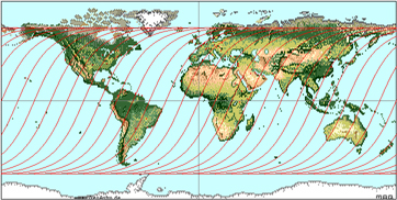
The Day and Night Terminator Across the Earth
Map
(c) Apple Computers, Inc.
The maps below are showing the
solar terminator at equidistant intervals of 1 hour.
Using the equirectangular projection map the
distortion (both shape and area) increases towards
the poles.
(1) Lines of simultaneous sunrise at summer
solstice (June 21, declination +23.4°)
and simultaneous sunset at winter solstice (December 22, declination
-23.4°):

(2) Lines of simultaneous sunset at winter solstice (December 22, declination -23.4°),
and simultaneous sunrise at summer solstice (June 21, declination +23.4°):
(3) Lines of simultaneous sunrise and sunset
at equinox
(March 21, September 23, declination
0°):

More:
maps showing the lines of equal solar altitude
Last update: 2023, Oct 07